Places worth discovering

Things to Do

Find attractions, experiences and places to visit. Events remain the best way to see what is happening on a particular date.

Looking for a dated event? Explore Events

139 places

Explore local places

Mendooran Mural Town

Landmarks and Buildings

Mendooran Mural Town

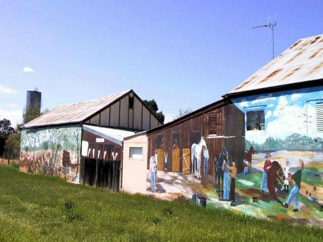
Take a leisurely stroll through the village of Mendooran and admire the colourful murals that brighten the township. These artworks, many created by former resident artist Karen Duce, reflect the unique character and heritage of the area. A standout mural near the Royal Hotel captures a striking bullock team hauling a dray loaded with wool bales, offering a glimpse into Mendooran's pastoral past. Situated along the Castlereagh River, Mendooran is the oldest settlement on its banks and holds a strong reputation for horse sports. The town proudly hosts the annual Mendooran Rodeo and the historic Mendooran Cup, a racing event that has delighted visitors for more than 153 years. Travellers are welcome to enjoy free camping at the Mendooran Rest Area, which includes access to toilets, cold showers, and a dump point. For those seeking a warm meal and some comfort, the Royal Hotel serves delicious country-style food. Dining in also gives guests the opportunity to enjoy a refreshing hot shower. With a warm community atmosphere and a rich connection to history, Mendooran invites you to experience genuine country hospitality.

Mendooran NSW

0.9 km away

View place
Central West Cycle Trail

Natural Attractions

Central West Cycle Trail

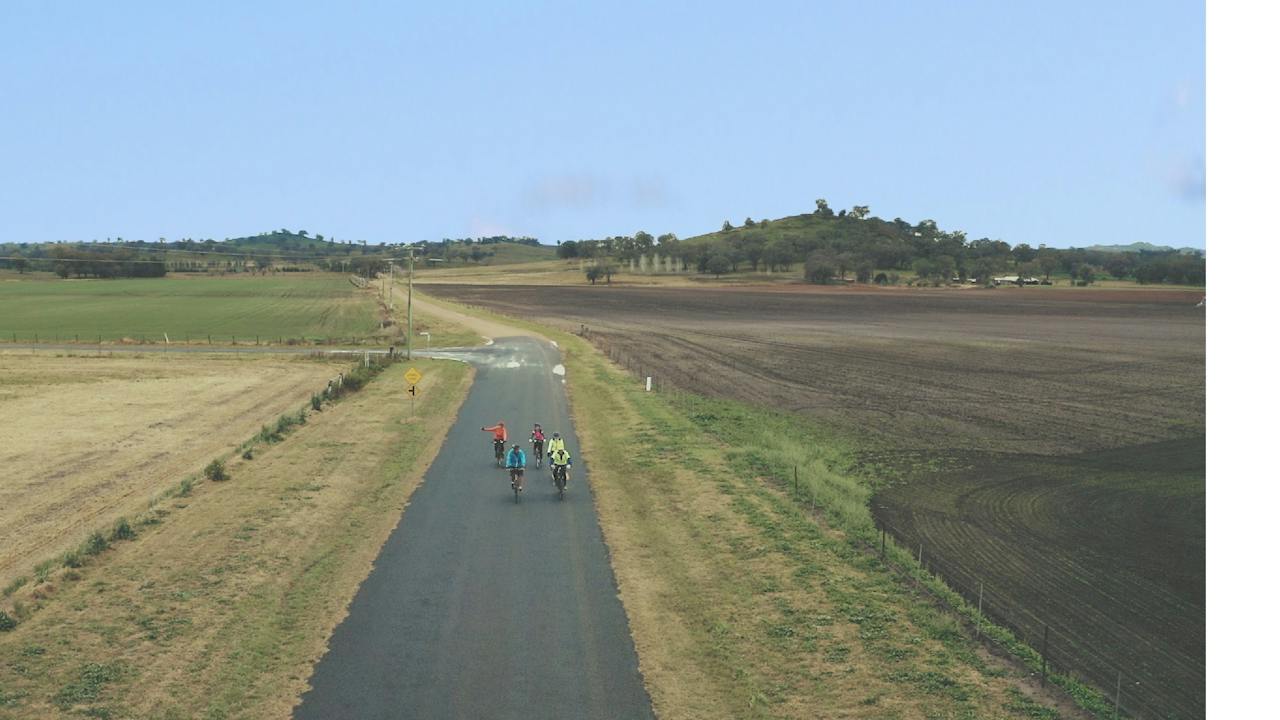
The Central West Cycle (CwC) trail creates a loop around the central west of NSW almost 400 kilometres. The CWC trail follows the quiet backroads in a circuit through Mudgee-Gulgong-Dunedoo- Mendooran-Ballimore-Dubbo-Geurie-Wellington-Goolma-Gulgong to Mudgee. A few busier sections have to be traversed as links to the next quiet road. It is a very generous bike trail designed to give cyclists day rides or a week-long ride with a great, memorable cycling experience. All towns have accommodation as well. The loop encourages new visitors to come to the Central West of NSW and breathe life into the small villages and towns. Furthermore, the CWC trail travels through Wiradjuri country, providing participants to experience the landscape and early Colonial Australian History including “Explorers” ”Bushrangers” “Goldfields” and “Pastoral Runs” and cycle an ever-changing landscape of Towns, Villages, Farming, National Park and Reserves. When you visit the website, make sure you click on CWC in the toolbar, which will take you to the area you need for this ride.

Mendooran NSW

1.0 km away

View place
Dunedoo Central West Cycle Trail

Natural Attractions

Dunedoo Central West Cycle Trail

The Central West Cycle (CWC) trail creates a loop around the central west of New South Wales of almost 400 kilometres. The CWC trail follows the quiet backroads in a circuit through Mudgee-Gulgong-Dunedoo- Mendooran-Ballimore-Dubbo-Geurie-Wellington-Goolma-Gulgong to Mudgee. A few busier sections have to be traversed as links to the next quiet road. It is a very generous bike trail designed to give cyclists day rides or a week-long ride with a great, memorable cycling experience. All towns have accommodation as well. The loop encourages new visitors to come to the Central West and breathe life into the small villages and towns. Furthermore, the CWC trail travels through Wiradjuri country, providing participants to experience the landscape, Early Colonial Australian History including “Explorers” ”Bushrangers” “Goldfields” and “Pastoral Runs” and cycle an ever-changing landscape of towns, villages, farming, National Park and reserves. When you visit the website make sure you click on CWC in the toolbar which will take you to the area you need for this ride.

Dunedoo NSW

34 km away

View place
Dunedoo Museum and Railway Station

Galleries, Museums and Collections

Dunedoo Museum and Railway Station

The Dunedoo Museum is home to the Dunedoo Historical Society, located on the Main Street of Dunedoo at the Old Westpac Building. The building also houses the local library which value adds to the Museum with its collection of local history books and photos. The Museum has both an in-house display of memorabilia including mining history, agricultural history, military history, First Nations artefacts, and household supplies, as well as external displays that are open to the public 24/7. The collection is sure to take you on a trip down memory lane! Situated opposite the museum is a park with barbeque facilities and amenities and next door is a Cafe and Bakery. The Museum is an ideal stopping point for visitors and groups (including school groups) to take a wander and relive some of the early history of Dunedoo and surrounding villages. Drop into the museum, have a chat with the locals and learn about the history of Dunedoo. Local history talks are available.

Dunedoo NSW

34 km away

View place
O.L. Milling Lions Park

Parks and Gardens

O.L. Milling Lions Park

Running the full length of Dunedoo's main street, the park features free barbecue facilities, an enclosed playground, two amenity blocks and a skate park. Of particular interest are the beautiful sculptures of birds native to the Dunedoo region, fabricated from recycled metal and farm machinery parts by David Sherlock. The park is also part of the 'Worlds Largest Virtual Solar System Drive' and holds Made and Grown Markets held seasonally. The new addition to the scenery of this area is the painted Silo of the horse Winx, and jockey Hugh Bowman was born in Dunedoo..

Dunedoo NSW

34 km away

View place
Dunedoo Silo Art

Landmarks and Buildings

Dunedoo Silo Art

The Dunedoo Development Group secured a State Government Grant at the end of 2019 to have the Silos painted and become part of the ‘Australian Art Silo Trail’. The Grain Silos were opened in 1936 and were closed by Graincorp, along with 72 other silos in NSW, in 2014. The Silo is now privately owned by a local farmer, Mr Brett Yeo. The artist commissioned to paint the silos was Mr Peter Mortimore and his wife Carolyn (nee Nott, who grew up in Dunedoo). The eastern side depicts local jockey Hugh Bowman, with his winning gesture- ‘She’s Apples’, with the mighty Winx and trainer Chris Waller. On the southern and western side the silo depicts the Dunedoo and District local rural landscape including Black Swans flying overhead. Dunedoo is derived from the Wiradjuri language for Black Swan.

Dunedoo NSW

34 km away

View place
Peppermint Tree Cottage Crafts

Shopping and Markets

Peppermint Tree Cottage Crafts

Peppermint Tree Cottage Crafts is nestled in the main street of Binnaway. Take time to explore this charming craft shop and book exchange. Here you will find an interesting range of homemade local arts and crafts including hand-knitted jumpers, wooden toys, and beautiful patchwork quilts. There is also a great range of Binnaway souvenirs available including t-shirts, caps, coffee mugs, glasses, and magnets. You can also pick up information on the Warrumbungle region for day visits or if you would like to stay on and take your time visiting the local attractions. Also available at Binnaway are cafés and hotels for yummy meals.

Binnaway NSW

39 km away

View place
Self Drive Geology and Nature Trails

Natural Attractions

Self Drive Geology and Nature Trails

Discover ancient lava flows, wonderful wildflower displays and evidence of the rich geological history of the Warrumbungle Region on one of these rewarding self-drive nature trails. Gamble Creek Nature Tour, is a 70 kilometre return trip to Binnaway. Greenbah Creek Nature Tour is a 30 kilometre return trip to Binnaway. Please note the touring route is unsealed.

Binnaway NSW

39 km away

View place
Dunedoo Woodland Learning Centre

Natural Attractions

Dunedoo Woodland Learning Centre

The Dunedoo Woodland Learning Centre includes interpretive signage and is home to remnant endangered Grassy Box Woodland which is a diverse mix of species dominated by White Box, Yellow Box and/or Blakely's Red Gum trees and a ground layer usually dominated by perennial grass tussocks. The two-four kilometre walking track meanders through 33 acres of Grassy Box Woodlands which used to dominate the Central West region but is now listed as an endangered ecological community in Australia under the NSW Threatened Species Conservation Act 1995. Less than one percent of the original Box-gum woodlands land remains with over five million acres destroyed.. The woodlands are located on Avonside Road near the Dunedoo Cemetery, just five minutes from town. The Dunedoo Woodlands are managed by the Dunedoo Coolah Landcare.

Dunedoo NSW

39 km away

View place
With updated wide footpaths, the Windmill Walk is accessible for prams and wheelchair
Image credit: GSC

Natural Attractions

Windmill Walk

Enjoy a relaxed, accessible riverside stroll on Gilgandra's Windmill Walk. This two-kilometre (one-way) path links the Coo-ee Heritage and Visitor Information Centre with the Gilgandra CBD and follows the Castlereagh River through native flora, birdlife and peaceful country scenery. Along the way, discover historic windmills brought back to life with bright artworks created by local disability services – a colourful highlight that celebrates community spirit. The walk is pet friendly, family friendly and offers picnic facilities for an easy outdoor break. The Windmill Walk is also a popular community route, used weekly by the Gil Run Club and as part of the annual Colour Run during Goin' to Gil weekend. It's an inviting, scenic and accessible way to experience the Gilgandra Region.

Gilgandra NSW

44 km away

View place
Meet Donna!

Shopping and Markets

This N That

Owner of This N That, Donna invites you into her exquisite shop, located in Gilgandra, Central West New South Wales. As the name suggests, Donna's little shop has a curated collection of unique and eclectic products - there is something special for everyone! Make sure to pop into This N That for a visit or send an email to say hi!

Gilgandra NSW

44 km away

View place
Hunter Park

Parks and Gardens

Hunter Park

Relax and unwind at Hunter Park, one of Gilgandra's favourite family-friendly green spaces. Shaded by magnificent century-old plane trees, the park is perfect for picnics and outdoor catch-ups. Kids will love the modern playground and skate park, while visitors can make use of the public barbecues and enjoy easy access to the Gilgandra Swimming Pool. Just 200 metres from the Gilgandra CBD, Hunter Park is an ideal spot to pair with a coffee run or takeaway picnic from nearby cafés. After your visit, wander the short distance to local boutiques and explore more of what the Gilgandra Region has to offer. Hunter Park delivers a convenient, central and welcoming outdoor space for families, travellers and anyone wanting to experience Gilgandra's relaxed country lifestyle.

Gilgandra NSW

44 km away

View place
Gilgandra Museum
Image credit: Gilgandra Region

Galleries, Museums and Collections

Gilgandra Museum

The Gilgandra Museum is run by the Gilgandra Museum and Historical Society. An extensive and exciting range of agricultural plant and machinery is housed in the Museum. Items of interest include -Howard Rotary Hoe, Ruston Proctor Steam Traction Engine, Titan Tractor, Ajax Gas Producer, McKay Harvester and McCormick Deering Tractor. Within the grounds of the Rural Museum can be found - Tooraweenah Police Gaol, Uargon Subsidised School, the famous Berida Sheep Station bookkeeper's office and residence and the Bullagreen Station shearer's quarters. These buildings contain local items from bygone days from kitchenware to doctor's instruments and hospital equipment.

Gilgandra NSW

45 km away

View place
The Coo-ee Heritage Centre
Image credit: GSC

Galleries, Museums and Collections

Coo-ee Heritage & Visitor Information Centre

Discover the best of Gilgandra at the Coo-ee Heritage and Visitor Information Centre – your first stop for exploring the region's stories, local attractions and country hospitality. Knowledgeable staff and volunteers are on hand to help you plan your visit, share insider tips, and point you toward the unique experiences that make the Gilgandra Region such a memorable destination. Located at the trailhead of the scenic Windmill Walk, the centre is the perfect starting point for a leisurely stroll into Gilgandra's town centre. Along the way, enjoy local cafes, boutique shopping, vibrant public art, country pubs and a host of community treasures that showcase the charm of this riverside town. Whether you're chasing history, outdoor adventure or local flavour, the Coo-ee Heritage and Visitor Information Centre is here to guide you. Drop in, say hello, and let the team help you make the most of your time in the Gilgandra Region

Gilgandra NSW

45 km away

View place
Tooraweenah Park

Parks and Gardens

Tooraweenah Park

Tooraweenah Park sits in the centre of this historic village, known for its early 20th-century buildings and views toward the Warrumbungle National Park. The park features modern play equipment, shaded picnic areas, barbecues and public toilets—ideal for a family stop or road-trip break. Visitors can also enjoy the cricket nets, tennis courts, hit-up wall, basketball ring and open sporting field. While in Tooraweenah, visit the country pub across the road and follow the town's historic walking trail to the GK Rohr Warrumbungle Viewing Platform for standout mountain views.

Tooraweenah NSW

46 km away

View place
King Togees Grave

Historical Sites and Heritage Locations

King Togees Grave

If you have a keen interest in Aboriginal history, the grave of King Togee is to be found 29 kilometres west of Coolah on the left-hand side of the Neilrex Road, just past the 'Langdon' homestead. There is a weather-worn sandstone headstone surrounded by four white posts with a sign overhead reading 'Togee King of the Butheroe Tribe'. King Togee was friendly with the early settlers but was speared to death by a young man named Cuttabush, who later became the king of a Coonabarabran sub-tribe. Please contact Pandora Gallery at Coolah for more information.

Coolah NSW

47 km away

View place
Black Stump Rest Area

Historical Sites and Heritage Locations

Black Stump Rest Area

Coolah is one of several towns to claim bragging rights as the home of the legendary Black Stump. It was here that the colloquial saying ‘Beyond the Black Stump’, meaning ‘beyond the limits of civilisation’ is said to have originated. Supporting Coolah’s claim is a document showing land boundaries declared by Governor Darling in 1826. This boundary line passes through the centre of a property known as ‘Black Stump Run’. The local Aboriginal Gamilaraay people called the area ‘Weetalibah-Wallangan’, meaning ‘the place where the fire went out and left a burnt stump’. In 1905, a fire engulfed the Black Stump Wine Saloon, which was said to be the location of the original black stump. Today, a rest area and replica stump mark the historic location. It contains picnic shelters, an electric barbecue and flushing toilets. Be sure to visit the township of Coolah, which is close by and offers accommodation and great food choices.

Coolah NSW

57 km away

View place
Pandora Gallery

Galleries, Museums and Collections

Pandora Gallery

The Pandora Gallery provides regional artists with the opportunity to exhibit in Coolah located along the Black Stump Way in Central West New South Wales. The gallery features enlargements of renowned photographer Max Dupain (circa 1947) permanently mounted for public viewing, with exhibits changed on a monthly basis. Pandora Gallery is situated in the Art-deco style of the 1930s, where renovations have enhanced the personality and charm of the period. Also within the complex is the Information Centre, local library, meeting rooms, and gym.

Coolah NSW

57 km away

View place
Coolah Crafts

Shopping and Markets

Coolah Crafts

Take a stroll through a unique and exquisite craft shop at Coolah Crafts, where you will find a large variety of locally made country handcrafts, including woodwork and ceramics. You will also find patchwork and jewellery designed by local artisan Annette Piper. Sample delicious homemade condiments and treats or make a purchase from their beautiful wool and haberdashery display. Coolah Crafts is a must-see when visiting or travelling through town, and Thursday is cake day. Make some time and call in!

Coolah NSW

57 km away

View place
Two Dams picnic area

Natural Attractions

Two Dams picnic area

Two Dams picnic area is a great place to pause amidst the bushland beauty of Beni State Conservation Area. As the name suggests, this picnic area is positioned near two small dams. Its location, just 10km from Dubbo CBD, makes it easy for stopping in before work, during a lunch break or while travelling. Watching and sitting by the water is a great way to relax and unwind. Pack a thermos or some lunch and take a seat at the picnic table, or simply bring a water bottle to rehydrate after bushwalking or cycling. At Two Dams picnic area, you can also enjoy birdwatching to your heart’s content. As well as ducks and waterfowl, you’ll find a colourful range of woodland birds you’d never have the chance to see in the city. Look out also for animals nearby – wallabies often stop in for a drink at the dams.

Dubbo NSW

58 km away

View place
Whitegum lookout

Natural Attractions

Whitegum lookout

Spectacular views of the volcanic landscape of Warrumbungle National Park await you at Whitegum lookout. Be sure to take a hamper or thermos flask if you want to relax at the picnic tables near the carpark after taking in the view and snapping some photographs. It is a 500m stroll from the carpark to Whitegum lookout along a sealed pathway. Although there is a slight incline, the path is suitable for wheelchairs and prams and it is an easy walk for children.

Tonderburine NSW

59 km away

View place
Breadknife and Grand High Tops Walk

Natural Attractions

Breadknife and Grand High Tops Walk

This iconic Warrumbungle National Park walk is famous for its wildlife and vistas of rugged volcanic landscape. Breadknife and Grand High Tops walk is the jewel in the glistening crown and is a must-do for bush walkers who love a challenge with their scenery. The track follows Spirey Creek before climbing steeply to give close encounters with iconic formations such as Belougery Spire, Bress Peak and Crater Bluff. Passing Balor Hut campground on your way up, stop for a picnic and take in one of the best panoramas in NSW. After the breathtaking Grand High Tops summit, continue on towards Western High Tops and the Ogma Gap campground. You'll pass Dows Camp on the way for a look at the impressive Bluff Mountain. To complete the 14.5 kilometre loop, follow the West Spirey track back to Pincham carpark. Alternatively, you can take a shorter 12.5 kilometre return to Pincham carpark via Dagda Shortcut. In spring, walkers will be treated to a wildflower display of purple hoveas, white daisy bushes, yellow wattles and orange pea flowers.

Warrumbungle NSW

59 km away

View place
Beni State Conservation Area

Natural Attractions

Beni State Conservation Area

Excellent birdwatching, bushwalking, picnicking, cycling and horse riding opportunities await you at Beni State Conservation Area, near Dubbo in Central West NSW. Discover a peaceful oasis just 10km from central Dubbo at Beni State Conservation Area. Offering an idyllic bush experience a stone’s throw from the city, this central west NSW park is loved for its bushwalking and cycling opportunities. With its fresh air and inviting tracks and trails, you can’t help but feel energised when you visit. Experience cycling, or bring your horse along for horse riding. Check out the area’s scenic landscape and Aboriginal cultural heritage before relaxing with a packed lunch at Two Dams picnic area. If you like birdwatching, you’re in for a treat at Beni. It’s home to over 140 bird species, including several threatened woodland and waterbirds. Sit and listen as the melody of birdsong mixes with the call of frogs at sunset. And if you’re lucky, you may even see a possum or a wallaby hopping by.

Beni NSW

60 km away

View place
Terramungamine Rock Grooves

Historical Sites and Heritage Locations

Terramungamine Rock Grooves

Be amazed by the 150 rock carvings created by the Tubbagah people at the Terramungamine Rock Grooves. The site of ancient rocks is of historical significance and is located along the Macquarie River. It was used by the Wiradjuri Tribe to shape tools and spears and was an important meeting place for the Tubbagah people.

Dubbo NSW

61 km away

View place

What is happening now?

Search dated events, markets, live music, sport and community activities.

Explore Events

Planning by place?

Use Things to Do for attractions and experiences that are not tied to one event date.